26 June 2010
GREGORY NATIONAL PARK – WICKHAM TRACK, MOUNT SANDFORD HUMBERT RIVER ROAD FROM FISH HOLE
We had to back track about 600 metres over the rocky creek bed and tricky corner and then go south about 300 metres to the Wickham track.
It is amazing how totally different the three tracks in the park are.
Hubby said to me that the track has not been used for a while once we were on it. It sure was in use today as three cars passed us going north. Apparently more people are coming out to explore this area.
In places it was difficult to see the track ahead.
In places it was smooth in others a bit bumpy.
The scenery again was very different.
There were many creek crossings and water channel crossings. Hubby referred to this one as a hiccup to the smooth running track at the time.
Often the creek bed was quite dry
but on either side were lovely water pools.
After one creek crossing we were hit by a swarm of locusts. They continued with us for quite a while.
The jump up on the way up very interesting.
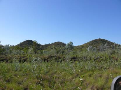
This time there was a real sense of going up to something. The views from the top were spectacular. The so called tent hills in the distance were very striking.
On the way down needed low 2nd gear. It was a short distance down and very deceiving. Didn’t look bad but all advice was use low gear up or down on this stretch.
As we approached Wickham river we wandered whether we would make it as this branch was low and the question was whether we could dodge it or whether we would have to cut it. We just made it as there was a ditch in the track.
Wickham River was beautiful.
There were no boabs on this stretch of the road. Lots of different types of wattles were seen along this stretch of the track.
Some trees were really into doing a contortion act.
There were quite a few cattle around on this track. We didn’t know whether this one was going to charge us or go the other way. Lucky for us it turned and went away.
Most of the track was more forgiving on the car – not as strenuous. It was the first time we came across a sign indicating that we were going past ceremony country.
At a spot where we were expecting a track to the river we came across a sign indicating that beyond that point on the road to the right was a sacred site and no sign of the expected track was to be seen.
We knew we were out of the park when we saw fences appear.
At the end of the Wickham Track we turned left to go along the Mount Sandford Humbert River Road. Note how insignificant the track to the left looks.
This second part of trip towards Humbert Station was full of surprises.
First 11 kilometres very hard on the tyres as some of it was along a channel of the Wickham River over loose stones. At times it was about kilometre in length in other places less. I measured one section as being 600 metres. This part of the so called road was very daunting when you couldn’t see the end to it.
You felt as if you were driving in a gorge with the Wickham River just beyond the grasses and the escarpment rising on the other side. There was no opportunity to decide to go back as there was no way you could turn around.
There were quite a few creek crossings along the way.
We didn’t have any track notes for this and wondered what we were in for as we drove between long grasses and tall shrubs. In places the grasses nearly obscured the track. They were also quite tall – above the window in places and we do sit very high up compared to an average 4wd.
At times it was spot where the track is going.
Then about eleven kilometres in after a creek crossing to our surprise a graded road was in front of us. From then on it was generally smooth sailing.
The last creek crossing was wet black soil. Hubby got quite worried as he crossed it. He felt the back wheels begin to sink in. Luckily there was a rock base on exiting it.
Eight gates had to be opened and shut before reaching Buchanan Highway.
As we left through the last of Humbert Station gates there was a sense of relief that we had got through this part of the trip safely and with the car intact. None of the drawers or cupboards swung open through the rough tracks. Only the fridge had jumped around a bit in its lodgings.
The trip through Gregory National Park was absolutely awesome. A beautiful place. It sure has plenty of flies, termite mounds and birds. Each track had its own beauty and challenges. The Bullita Stock Route was the most difficult. The highlights here were the two East Baines River crossings and the limestone steps. The next in difficulty was the Humbert track. The highlight here was crossing the Humbert River. The Wickham track was the most picturesque. The highlight here was the jump up.
We will do it again if possible.
Showing posts with label 4WD. Show all posts
Monday, June 28, 2010
DAYS 61-62 FROM SOUTH TO NORTH - TOP END (NORTHERN TERRITORY) TRIP
24-25 June 2010
JUTPURRA / GREGORY NATIONAL PARK – Bullita Stock Route
We finally made it here. It was on our wish list during our Kimberley trip two years ago but a bit out of the way then and not do able because of timeframes for the trip.
We planned to do this before going to Darwin but for reasons mentioned in the blog earlier during these travels it did not eventuate at that time. Well we are finally here and on our way through the park. We have notified our daughter in the event that we are not back by the 29th to raise an alarm. The information about the park describes this as a remote 4WD experience requiring you to be self-sufficient and self-reliant. As we drove into the park we met two cars coming out so maybe not as remote as all that. The most striking feature driving in was the abundance of termite mounds – like headstones in cemetery.
It was not far from the campsite to Bullita – about 16 kilometres along a gravel road. The vegetation is not as green as in Kakadu and the creek crossings were generally dry with some water pools on either side of the crossing in places.
Our first stop was Bullita. Bullita is the sector in Gregory National Park’s that is a reminder of the pastoral past of the area. Current homestead was built in 1960 and replaced a couple of iron igloos as it was an outstation of Humbert River Station. It became a separate station under Harry and Lyn Berlowitz.
It was a hard life for those living here. The last owners of the Bullita Station lived here for 10 years – till just after the 1977 floods. The incredible harrowing experience during the flood by Mrs Berlowitz is recorded in a detailed letter she had written. It all started with the flooding from the river behind the homestead.
Today our focus was on Bullita Stock Route – what is considered to be a difficult one way track that explores the north west section of the park. It follows a section of the old stock route to Wyndham.
The reason it is one way is because of the East Baines crossing and the jump up at Spring Creek Yard can only be negotiated in one direction.
We set out with some trepidation. It was a slow trip. Sometimes the speedo was not registering the speed of travel. The fastest we reached was 25 km per hour and that would have been for a 100 metres may be a little further at times. The first crossing of the East Baines River we approached with caution. Markers marked the route along the crossing with the instruction to keep to the left of them.
There were several bends to negotiate. As we approached the last bend lo and behold a crocodile was swimming in front of us. It totally caught us by surprise and momentarily we lost concentration on following the markers – but all was well. I couldn’t refocus the camera quickly enough before it went under water. It is a shadow in the photo below.
The track was ever changing.
We zig zagged between trees, termite mounds, termite mounds and trees whilst dodging overhanging branches and bounced and rocked from side to side as the Oka made its way over the uneven surface. At times there was a hump or a one sided drop as well that added another dimension to all the obstacles listed above.
The path was exceptionally cleared marked with cairns in a few places. The main markers were blue triangles and blue boab tree markers noting distance traveled.
.
Hubby tells me it was the roughest 4WD he has done in 40 years. Negotiating down the limestone steps after the insignificant jump up required precision wheel placement. You could see a lot of scrapes on the limestone where precision was lacking by some drivers.
After the limestone steps there was a section with interesting limestone outcrops to the side.
The first ten kilometers were probably the most challenging overall except for specific short sections later on.
Someone told us the track was boring. Well we found it very interesting. It was constantly changing either due to the track surface or vegetation.
We stopped for lunch at the beautiful Spring Creek Camping Ground.
Don’t the termite mounds look like fingers of a hand!
The campground is located at the scenic Spring Creek.
Then after lunch we were on our way again. The termite mounds are actually quite high. To provide a perception of their height I got hubby to stand next to one.
The stock men labelled some of the boabs with hotel names. These labelled boabs were meeting places for the stockmen. This one was the Oriental Hotel.
It was huge in size. You could not have missed it on route.
We had been hitting low level branches on and off for most of the trip – it was just not possible to dodge them all. I had quite a bit of debris come flying in through my window. Hubby decided to check what was happening on top – well . . .. quite a few branches, twigs and leaves had found a home up there.
Then across Spring Creek we had to go.
There was some water to the side of the crossing and a little at the beginning of the crossing.
Then another dry river crossing with a steep entry.
This was followed with lots of bouncing and rolling from side to side.
Then just over a kilometer of stoney track
and then half decent track
past a limestone escarpment.
Then suddenly we said ‘holey dooley’ as we looked down at the beginnng of the East Baines River Crossing. All I can say is thank goodness it had no water in it ie across the crossing. We looked down the 45 degree angle and could see a bend and wandered what else was in store.
I made my way down via a side track that was more stepped as there was no way you could walk down the drop that was the track.
Hubby slowly made his way down.
Then made his way through a reasonably sharp turn before reaching the river bed.
I got back in before negotiating the river bed. I didn’t see the markers in the river but apparently he did. There were many twist and turns through the river bed.
Finally the end was in sight as we started to go back up.
We left the track to do the side trip to Drovers Rest. This boab was just so ‘elegant and graceful’.
Another check to see that all is right with the vehicle before continuing on.
This section was somewhat greener and the track was slightly better in that you travel slightly faster ie 20-25 km per hour for short distances.
The landscape changed as hills started to appear rising out of the flat surroundings.
On Day 1 we made it to Drover’s Rest campsite above the the Barrabarrac Creek. About 40km along the stock route. It took us five hours with a lunch stop to get here.
The creek here is lined with pandanus palms. No swimming again - not safe.
The campsite has boabs amongst the trees that lit up beautifully before sunset.
They provided a lovely backdrop as I quilted before dinner.
Day 2
The second day on the Bullita stock Route was a lot easier and allowed for faster travel. It took 2 hours and 25 minutes to do 40 kilometres of the track.
We saw monitor tracks over our car tracks as we drove back to rejoin the stock route.
The boabs are just so unique. There were even some boab nuts on the ground. A pity that most of them were cracked.
Termite mounds dominate the landscape throughout the track.
Once back on the stock route the track deteriorated and was much slower for part of the way.
Then a little oasis to the side. A short track to the side led to a very scenic section of the Barrabarrac Creek.
On the other side it was slightly hilly.
The next five kilometers involved a number of climbing sections with many turns. In one place hubby engaged first low to keep it slow and steady over a steep rocky climb.
Throughout the track we have intermittently seen kapok yellow flowers. The tree looks dead except for the flowers. Once it flowers it will grow its fruit/seeds and then the leaves will return. The aborigines use the kapok tree as an indicator. When the leaves drop off and it flowers it indicates that the fresh water crocodile is laying its eggs. When the flowers die and the seed sets the fresh water crocodile eggs are hatching.
The knock them down rain has hit this side of the park as the grasses are lying doubled over. In most of the park they were still standing erect.
The last 12 kilometres to the main road from Timber Creek to Bullita was relatively easy going except for some washouts.
A combi by the side of the road had obviously come in the wrong way and was going nowhere. It has been here for a while.
Once we turned into the main road to Bullita we considered this part of the track finished. It was a great experience and the first bit of really serious four wheel driving we had done in the OKa. It felt good and boosted our confidence for the future.
Subscribe to:
Posts (Atom)