Showing posts with label Gurig Gunak Barlu National Park_Cobourg Peninsula. Show all posts

Tuesday, June 22, 2010

DAY 53 FROM SOUTH TO NORTH - TOP END (NORTHERN TERRITORY) TRIP

16 June 2010

GURIG GUNAK BARLU NATIONAL PARK, COBOURG PENINSULA


A day for contemplation, relaxation and soaking in the environment.

During our stay the temperature has become milder, but it is still hot. It has been sitting around 28 to 30 degrees. In the mornings there has been a breeze, but no afternoon breeze.


Initially there were a lot of insects around but the last two nights their numbers decreased dramatically. Don’t know if our insect repellent strategy was working or whether there were just fewer insects. However, there are lots and lots of dragon flies and butterflies.


Some nights we heard frogs croaking and at dusk flocks of birds would fly noisily past – their bird calls could be heard from afar as they flew.


Lots of evidence of wildlife here. But do you think we saw any? No! We even went night spotting and still didn’t see any.


We spent quite some time today at Smith Point. We walked along the beach, hubby walked to the beach huts whilst I quilted enjoying million dollar views. Hubby threw in a line but no luck. We’ve heard that although this is a good fishing spot during the last week no one has been catching much even those going out in boats. The literature told us that the best time to fish here is once the tourist season closes.


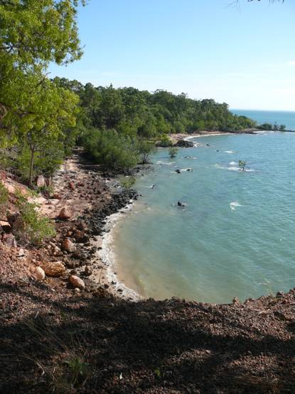
Five rangers are stationed at Black Point to look after the huge park that takes in the entire peninsula, surrounding water of Arafura Sea and Van Dieman’s Gulf and some of the neighbouring islands. It covers over 4,500sq km. It is huge. Coburg is also full of history, it is beautiful, picturesque, serene. You don’t‘ feel as if there are people here. I have no idea how many are here at this stage. You hardly see anyone.


The campsites are very secluded and well set up. The campground is set up in such a way that all sites are very private and restful. Campsite 2 is for those with generators and the campsites here are also spread out and secluded. Some campsites have shades whilst others do not.


The toilet block is great


and they have hot showers.


I would highly recommend this area for a visit.


It is unique and very scenic and we are just so glad that we did come here.


We went down on the beach again for the final sunset.

Monday, June 21, 2010

DAY 52 FROM SOUTH TO NORTH - TOP END (NORTHERN TERRITORY) TRIP

15 June 2010

GURIG GUNAK BARLU NATIONAL PARK, COBOURG PENINSULA – VICTORIA SETTLEMENT


Exploration of the history of the area was the theme today.  We took a tour to Victoria Settlement as that was the only way we could get to see it. It is 25km away and access is by boat only.


It was the third and longest lived in settlement that the British tried to establish in this part of northern part of Austrlia to protect its interest in this region. Before the British, Macassans travelled to this area of Asutralia from Suilawesi in search of sea slugs. This formed the basis of a flourishing trade between Macaasans and China.


At 8.00am we gathered near the boat ramp at Black Point for our trip down to Port Essington. The boat just powered through the water – thump thump thump. It took about 40 minutes to get there.


What an isolated place for settlement! Our first glimse of it was what remained of the jetty. Through the trees we could see the ruins of the hospital. The settlement was established in November 1838. What a time to arrive from England to face a hot monsoon season. Their clothes were not suitable for the climate. They must have melted in the heat. Apparently the village sprng up very quickly as they brought some ‚prefab‘ buildings considered essential for the settlement from Sydney. They had a Government House and church that no longer exist as a cyclone destroyed most of the settlement a little more than a year later. So what is feft:
- the Magazine,


- five cottages that were the married quarter


- the foundations of the Quartermaster’s store that initially was the first hospital in the settlement


- the blacksmith’s forge


- the well
- the hospital kitchen


and foundations of the hospital wards


- the hospital dispensary


- Original Quartermaster’s store


- the bakery


- the Lime Kiln


- the cemetery


-and finally the jetty.


From the seventh year the settlement went into decline due to its isolation, oppressive conditions, climate and in large part to malaria. The settlement was finally abandoned in November 1849. A new settlement was then established in what is now Darwin.

It would have been a very hard life here for garrison members and their families. Most of those who died here did so as a result of getting malaria and in those days they did not know what it was nor how to cure those who got it.

Besides its isolation the settlers enjoyed million dollar views.


The jetty ruin now has an interesting root structure establishing itself on it.


After the 3.7 km walk through the settlement it was time to leave. We had a bit of ‘fun’ leaving as the men had to help push the boat out due to the low tide.


As we passed a headland there was a huge croc sunning itself on the sand.


The boat turned around and went towards the shore as the croc turned around and made its way quickly to the water.


By the time it got in the water the boat was a the shore. It was scarry to see that once it was in the water we could not see it anywhere even though we knew it was within metres of us. Only the tracks were left in the sand that it had been there.


As we made our way back to Balck Point we enjoyed the passing shoreline which was constantly changing.


Just past Black Point a customs ship lay at anchor so we went out to it.


At midday we were back at Black Point in time for lunch and a relaxing afternoon.

DAY 51 FROM SOUTH TO NORTH - TOP END (NORTHERN TERRITORY) TRIP

14 June 2010

GURIG GUNAK BARLU NATIONAL PARK, COBOURG PENINSULA – SCENIC DRIVE


Today we really discovered the beauty of the peninsula.


We spent the better part of the day driving very slowly along the scenic drive.


It was about 18km from our campsite till we got back to the maintrack near the turn off to Caiman Creek. The drive was truly scenic.


We set out from our campsite past the crocoilde crossing. A couple camping at campsite 2 had seen two crocodiles on the beach just across from this crossing at different times yesterday.


We drove between 20 to 150 metres from the sea. Hubby’s GPs was teelling him that he was driving in the sea at this point whilst my map on the computer was showing us driving along the shore.


The scenery varied from savanah woodlands


to plains


to monsoon jungle.


The coast line also varied greatly.


The large rock ledges of Smith Point were not seen here.


In many places the sea had carved steep edges into the sand. At high tide the water was lapping against the carved out wall.


At one part of the coast, plant like material drapped the rocks.


Another part of the coastline showed damage from the recent cyclones here.


We were very aware of being in crocodile country. We constantly kept checking behind us to the side of us as the environment was definitely that of croc country. On top of that I would be looking out for snakes on the ground and pythons in trees. Someone was very amused by this and that wasn’t me. Hubby thought snakes were insignificant compared to crocodiles here.


After Lizard Bay the track turned west to take us back to the main road.


Termite mounds started to appear in this area


as we drove through a patchwork of burnt and unburnt woodland.


Along the way bird tracks on the sand kept us guessing what bird they belonged to.


There was evidence of Banteng but we did not see the animals themselves. You could see where crocs had made there way across grasses and at times left prints on the track.


One crab seemed happy sitting on the rocky shore line.


Tiny flowers brightened up the surrounding grasses.


Fruit was ripening on the pandanas


and in places it was scattered burnt on the ground after the recent burn off.  Apparently it is great fuel for a fire.


Again we had some manoevering issues to get through due to trees growing too close by or low branches. In the end hubby decided to take the aerial off in order to protect it.


At the main track we turned off again to go to see Caiman Creek as this is one of the fishing spots. There were interesting humps built on the track. The idea is that they protect the road from being washed out. They are quite tall and most 4Wds would be cursing going over them. In the Oka it was easy. You could see where they have tried going around them. In many places the rangers have put obstacles around the sides to stop them going around them.


There was a steep hill on this track. Whilst this is normal for us from the east it is considered unusual here in the territory.


Hubby decided he did not want to fish here.


There was a beautiful view in the distance of the distant shoreline.


Another lovely day in a special place.