Showing posts with label Gregory National Park/Jutpurra National Park. Show all posts

Monday, June 28, 2010

DAYS 63 FROM SOUTH TO NORTH - TOP END (NORTHERN TERRITORY) TRIP

26 June 2010

GREGORY NATIONAL PARK – WICKHAM TRACK, MOUNT SANDFORD HUMBERT RIVER ROAD FROM FISH HOLE


We had to back track about 600 metres over the rocky creek bed and tricky corner and then go south about 300 metres to the Wickham track.


It is amazing how totally different the three tracks in the park are.


Hubby said to me that the track has not been used for a while once we were on it. It sure was in use today as three cars passed us going north. Apparently more people are coming out to explore this area.

 In places it was difficult to see the track ahead.

In places it was smooth in others a bit bumpy.


The scenery again was very different.


There were many creek crossings and water channel crossings. Hubby referred to this one as a hiccup to the smooth running track at the time.


Often the creek bed was quite dry


but on either side were lovely water pools.


After one creek crossing we were hit by a swarm of locusts. They continued with us for quite a while.


The jump up on the way up very interesting.


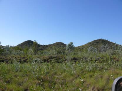
This time there was a real sense of going up to something.  The views from the top were spectacular. The so called tent hills in the distance were very striking.


On the way down needed low 2nd gear. It was a short distance down and very deceiving. Didn’t look bad but all advice was use low gear up or down on this stretch.


As we approached Wickham river we wandered whether we would make it as this branch was low and the question was whether we could dodge it or whether we would have to cut it. We just made it as there was a ditch in the track.


Wickham River was beautiful.


There were no boabs on this stretch of the road. Lots of different types of wattles were seen along this stretch of the track.


Some trees were really into doing a contortion act.


There were quite a few cattle around on this track. We didn’t know whether this one was going to charge us or go the other way. Lucky for us it turned and went away.


Most of the track was more forgiving on the car – not as strenuous. It was the first time we came across a sign indicating that we were going past ceremony country.


At a spot where we were expecting a track to the river we came across a sign indicating that beyond that point on the road to the right was a sacred site and no sign of the expected track was to be seen.


We knew we were out of the park when we saw fences appear.


At the end of the Wickham Track we turned left to go along the Mount Sandford Humbert River Road. Note how insignificant the track to the left looks.


This second part of trip towards Humbert Station was full of surprises.


First 11 kilometres very hard on the tyres as some of it was along a channel of the Wickham River over loose stones. At times it was about kilometre in length in other places less. I measured one section as being 600 metres. This part of the so called road was very daunting when you couldn’t see the end to it.


You felt as if you were driving in a gorge with the Wickham River just beyond the grasses and the escarpment rising on the other side. There was no opportunity to decide to go back as there was no way you could turn around.


There were quite a few creek crossings along the way.


We didn’t have any track notes for this and wondered what we were in for as we drove between long grasses and tall shrubs. In places the grasses nearly obscured the track. They were also quite tall – above the window in places and we do sit very high up compared to an average 4wd.


At times it was spot where the track is going.


Then about eleven kilometres in after a creek crossing to our surprise a graded road was in front of us. From then on it was generally smooth sailing.


The last creek crossing was wet black soil. Hubby got quite worried as he crossed it. He felt the back wheels begin to sink in. Luckily there was a rock base on exiting it.


Eight gates had to be opened and shut before reaching Buchanan Highway.


As we left through the last of Humbert Station gates there was a sense of relief that we had got through this part of the trip safely and with the car intact. None of the drawers or cupboards swung open through the rough tracks. Only the fridge had jumped around a bit in its lodgings.


The trip through Gregory National Park was absolutely awesome. A beautiful place. It sure has plenty of flies, termite mounds and birds. Each track had its own beauty and challenges. The Bullita Stock Route was the most difficult. The highlights here were the two East Baines River crossings and the limestone steps. The next in difficulty was the Humbert track. The highlight here was crossing the Humbert River. The Wickham track was the most picturesque. The highlight here was the jump up.

We will do it again if possible.

DAYS 62 FROM SOUTH TO NORTH - TOP END (NORTHERN TERRITORY) TRIP


25 June 2010


JUTPURRA/GREGORY NATIONAL PARK – Limestone Gorge and Humbert Track


Today provided a great variety in driving. We had some easy sections and some very difficult sections.


We only went as far as the Calcite Flow car park into the Limestone Gorge. The camping area in this part of the park has now been permanently closed. Access by road finishes at Calcite Flow car park.


Se we had a look at the Tufa Dams.


They were really interesting. They were created by the build up over rocks and trees of calcium carbonate deposits from the Limestone Creek.


We did the Calcite Flow Walk that took us to the lookout. The boab stands out for miles.


I zoomed in on it and just how beautiful it was!


Hubby did a great panorama with the calcite fall but the files was too big. So I had to use a single shot of the view that doesn’t really provide the impact of what we saw.


The calcite flow looked just like a waterfall.


The rocks here were very different and is known as rillenkarren. They had sharpish ridges. The aborigines used these rocks for spear heads, axes.


The track was Limestone Gorge was generally speaking in good condition except at the causeway. The recent rains washed away the track at both ends of the gorge making it no longer fully accessable to 2WDs because of the clearance required.


The Humbert Track was fairly easy going except for the creek and river crossings that presented a bit of a challenge. No dodging of trees on this track. The driving was slow but straight forward.


The scenery was diverse and interesting and very different to the Bullita Stock Route.


You got the feel that you could keep going at a good pace in third but before you knew it another creek crossing brought you back to earth. The creek crossings kept you on your tows. They were all different. Between the fourth creek and Figtree valley there large stands of boabs.


They were the last boabs that we would see as the further south we went there were no boabs.


Fig Tree camping area was a nice clearing beside a water hole. As hubby’s foot was still swollen we did not do this walk or the one to Police Creek Waterhole.  The jump up was a non event. We couldn’t tell when we were actually on top of it as there were no significant views to suggest it.  We think it was in the vicinity where the cows were on the track.


We were following track notes by the Savages and at this point started to look for the every ten kilometre blue boab marker as we were crossing more creeks than in the notes. In the notes only marked creeks were noted but there were many more water channels that we were classifying as creek with steep ups and downs.


We knew we were on the track as we kept seeing the blue triangles. We had crossed what we thought was definitely a river crossing as it was wide. It had steps going in and out of it that had to be negotiated.


It then rocked from side to side a sit made its way out of the river bed.


We were relieved when we saw this marker.


We were closer to Humbert River crossing than we thought we were. It was the next crossing. We stopped just before the edge going down. This is the crossing that they advise you to “walk the crossing first to familiarise yourself with the slope and layout of rocks”. I was glad we were not doing the track south to north as you wouldn’t see the rocks until you were well into the crossing because of the bend in the river. Lucky for us there was no water where these rocks were. The water was just past them. We had asked the ranger about this crossing in regards to crocodile safety as all track notes we saw said walk the crossing. For some reason this area seems to be croc safe.
So hubby went down to check it out.


I went down to see what it was all about.


I decided I was not going to be in the car whilst it negotiated the rocks. Hubby said the left side will be in the water and the right had side wheels will be driving along the path he was walking.


Just passed these rocks the river turns and you have a water crossing the rest of the way.


So here is the Oka making the crossing.


I got into the car with some difficulty because of the angle before the water part of the crossing.


It was only another 600 metres to the campsite – Top Humbert Yards. Whilst not far it was a creek crossing followed by a drive along a dry rocky water channel with an exceptionally tight bend. We had to do a three point turn on the bend.


The campsite had some ruins of the stock yards.


It was next to the Gunbunbu Waterhole.  We had a wash at tis edge but did not venture into it.


There was another family camping here. Not so remote a place as it seemed.


It was a lovely spot to enjoy the surrounds and relax with a nearly full moon, except for those sticky little flies.


At night fell we heard a pack of dingoes howling and the bray of donkeys. A very eerie sound.